
Basic (Passive) GeoServer Clustering
The objective of this document is to provide suggestions about how to best exploit the HW resources required with respect to the various software components of interests, namely, Apache Tomcat, GeoServer, and GeoWebCache in order to, on a side, implement an High Availability set up for each one of them to minimize the possibility of a service downtime and on the other side to achieve the maximum possible scalability in terms of number of concurrent requests that can be served for the unit of time with an acceptable response time. In the remaining part of this document we will assume that the reader possesses a decent knowledge of what the various software components do as well as the protocols they support. We will delve only into specifics related to the topic being discussed, that is properly dimensioning the deployment. In order to obtain reproducible numbers for the dimensioning of a host for GeoServer/GeoWebcache and Apache Tomcat capable to serve a certain number of concurrent requests, we have set-up a test environment and launched different stress-test against it, in order to test its limits.
Highly Available (HA) set up for GeoServer
Clustering GeoServer is required to implement an Highly Available set up as well as in order to achieve superior scalability. Regardless of the reason why one intends to create a clustered deployment for GeoServer there are a few limitations that must be taken into account and where possible worked around, let us now briefly introduce and discuss them.
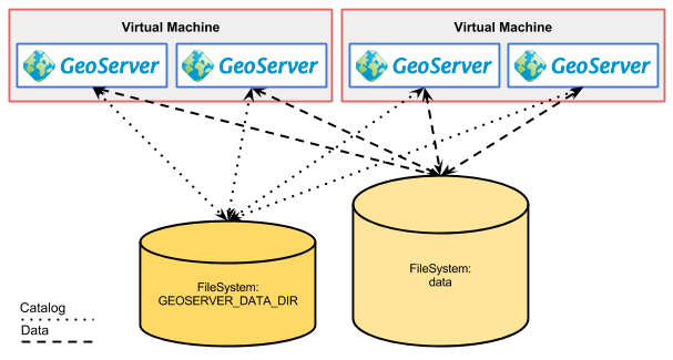
Illustration: Geoserver in cluster deploy
GeoServer Limitations
Data Directory
Currently the default persistence method for the internal configuration consists in a set of XML files contained inside a well-known directory called data directory (see the GeoServer material for additional information). This means that whenever we change the internal configuration and we persist the changes such changes are persisted in these XML files, moreover, whenever we need to load the internal configuration we need to read these files.
GeoServer comes with a built-in data directory. However, it is a good idea to separate the data from the application. Using an external data directory allows for much easier upgrades, since there is no risk of configuration information being overwritten. An external data directory also makes it easy to transfer your configuration elsewhere if desired. To point to an external data directory, you only need to edit the web.xml file. If you are new to GeoServer, you can copy (or just move) the data directory that comes with GeoServer to another location.
Following this, it becomes obvious that if we want to cluster multiple instances of GeoServer we must somehow share the same data directory in order to make sure that all the instances are identical. This can be achieved by either having the multiple instances share the same location for the geoserver_data variable or to act at a lower level and use file system replication to keep different locations in synch.
Internal Configuration
With the term GeoServer internal configuration we refer to the information that GeoServer manages and persists in order to perform its work. This information refers to, as an instance:
- Where the data is located
- How to connect to and serve such data
- How to manage incoming requests
and so on. Long story short, all the information that GeoServer needs for its proper working are represented within the internal configuration therefore every time we configure a new dataset or we change the way we want WMS to behave we interact with the internal configuration.
GeoServer’s configuration is stored by default in the Data Directory, as explained above, moreover, it is worth to point out that it is loaded in memory at start up and thereafter GeoServer assumes that the configuration resides in memory. The infrastructure within the GeoServer codebase that manages the memory copy of the internal configuration is called catalog (which should not be confused with the OGC concept of catalog) and contains the GeoServer’s internal object model where all the information of the internal configuration are represented by in memory Java objects and relations; access to the catalog is guarded via specific locks from both the user interface as well as from the REST interface in order to ensure that proper access it it’s guaranteed in every moment.
It is crucial to understand that changes made to the Data Directory are not picked up automatically by GeoServer; an operation called catalog reload needs to be issues to make GeoServer aware of the changes and such operation is available both form the GUI as well as from the REST interface.
Logging Configuration
GeoServer’s logging subsystem is quite flexible as we can decide whether or not we log onto the output stream (which usually means the internal logging mechanism for the enclosing Application Server as well as the location of the specific GeoServer’s own log file where only the log coming from GeoServer is written.
By default GeoServer’s log location is relative to the data directory, however regardless of its location when multiple GeoServer share the same data directory it is crucial to instruct them to log to different locations, this can be achieved via the GEOSERVER_LOG_LOCATION configuration tweak as described here. Setting this environmental variable to different locations for each GeoServer instance (i.e. Java process) allows us to properly configure each of them to write to a different log file avoiding any problem.
Java2D Rasterizer Bottleneck
Common Java installations come with two different rasterizers (the component that turns vector into raster images)
The Oracle JDK has a fast rasterizer, but one that can only rasterizer one shape at a time in the whole process when antialiasing is enabled. When generating images on server side in a concurrent environment, worker threads are blocked most of the times so the application does not scale at all. As soon as multiple clients request the generation of images, the response time increases. When you have more than 4 CPU, and if you are normally CPU bound, set-up multiple processes and use a load balancer to distribute the load among them.
The OpenJDK rasterizer, available on Linux, scales up well instead, but it’s slower when a single request is hitting the server. Generally speaking, the OpenJDK one catches up with the Oracle JDK one when 2-4 requests are running in parallel, and provides better performance from this point on.
A new open source rasterizer, the Marlin Renderer, is being worked on at GitHub, which provides best of both worlds: it is as fast, if not faster, than the Oracle JDK on isolated requests, but scales up as well as the OpenJDK one when the load goes up.
References
Where the data is located
The spatial data accessed by GeoServer doesn’t need to reside within the GeoServer data directory, just pointers to the data locations. This should be obvious for data stored in spatial databases, which are certainly in different locations (on disk) and often on different machines; however the same is true for file-based spatial data and this can be problematic for a clustered GeoServer instances since depending on the approach taken for clustering such instances we need to ensure that both the data directory as well as the data it points to are mapped in a proper way on the machines for the various instances.
Integrated GeoWebCache Configuration
Standard GeoServer comes with an integrated GeoWebCache instance to achieve map acceleration for tile based requests without the need for installing an additional piece of software. This capability is very good for small set up but might need special attention/configuration in clustered setups.
Residual limitations
Once all of the above configuration changes are completed the cluster is ready for production. If nothing in the configuration ever changes, or changes only rarely, we’ve got a good production environment.
Backoffice/Production configuration (separate Data Directory)
When a cluster of GeoServer with shared data directory is configured it’s advisable to setup an offline GeoServer working off a copy of the cluster data directory (staging area), make changes until a new satisfactory configuration layout is reached, and then propagate the changes to the production cluster with the following steps:
- Copy the data directory from the staging area to the production one
- Issue the “reload” REST configuration command on each node in the cluster so that the new configuration gets loaded on disk.
This approach starts showing its limitations when any of the following situations apply:
- Frequent configuration changes that need to be applied right away to the entire cluster
- The configuration contains many layers (hundreds or more) which implies a long reload time. During the reload phase the server is not really able to respond properly to OGC requests as the configuration is in an inconsistent and incomplete state
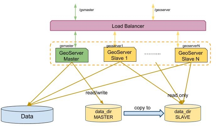
Illustration: Backoffice/Production
Master/Slave cluster with shared Data Directory
To understand how a cluster of GeoServer with shared data directory works, we have to explain how the configuration is actually handled.
In Memory Configuration
Besides the fact that the internal configuration for GeoServer is stored by default in XML files, it is worth to point out that currently the persistence subsystem loads thoroughly in memory at start up ( or reload ) the entire internal configuration as it is defined inside the XML files in the data directory assuming, after that time, that the configuration resides actually in memory.
The infrastructure within the GeoServer codebase that manages the in memory copy of the internal configuration is called catalog (which should not be confused with the OGC concept of catalog) and contains the GeoServer’s internal object model where all the information of the internal configuration are represented by in memory Java objects and relations; access to the catalog is guarded via specific locks from both the user interface as well as from the REST interface in order to ensure that proper access it it’s guaranteed in every moment.
Performing changes to the configuration
Changing something into the catalog via the GUI or via the REST interface in this configuration is not a simple or atomic operation. The fact that the internal catalog is kept pinned in memory by the GeoServer is relevant especially in a clustered environment since whenever a configuration change is made in one instance of GeoServer (the master) the other instances (the slaves) should not be aware of the change unless a full configuration reload is issued, moreover the internal configuration and catalog of GeoServer during a configuration reload is in an inconsistent state until when the loading has been performed and all the configuration objects have been created.
Along the same line it is worth to point out that when working with a cluster of GeoServer instances whenever we make a configuration change in an instance of the cluster we must reload the configuration of the other instances and this process becomes slower as we the configuration grows that is as more data is deployed.
Illustration: Geoserver in cluster: deploy schema